Log in
All resources
Create a design
9,296 Free Artworks of Map Collection
bibliothèque nationale de france
copper engraving print
british library
joan blaeu
atlas maior, vol 3 (germany) - joan blaeu, 1667 - bl 114.h(star).3
eran laor cartographic collection
paper
claes jansz. visscher (ii)
maps by thomas kitchin
thomas kitchin
maps from gallica
baroque
carte generale du tres-haut, tres-puissant et tres chrestien royaume de france
maps by nicolas sanson
sanson maps of asia
1670s maps of asia
pieter verbiest (ii)
maps from gallica
maps of prague by braun & hogenberg
maps of cheb by braun & hogenberg
maps of the course of the rhine by guillaume sanson
robert cordier (engraver)
maps by willem and johannes blaeu
17th-century maps of xaintonge
sanson maps of the circles of germany
bibliothèque nationale de france
johann friedrich walther
1738 in berlin-mitte
henri-charles landrin
vallée d'aspe
drawings by james mcneill whistler in the metropolitan museum of art
aestheticism
old maps of atlantis
island of california
engravings in the yale center for british art
samuel rawle
het zegepralent kennemerlant
hendrik de leth
bibliothèque nationale de france
maps of goa by linschoten
a map of the british empire in america with the french and spanish settlements adjacent thereto
bibliothèque nationale de france
territorium argentoratense (1652 map)
bibliothèque nationale de france
maps of cairo by braun & hogenberg
bibliothèque nationale de france
18th-century maps of portugal
maps by carolus allard
a map of the british empire in america with the french and spanish settlements adjacent thereto
bibliothèque nationale de france
maps of granada by braun & hogenberg
bibliothèque nationale de france
maps of the americas by mercator-hondius
maps by jodocus hondius ii
maps of the americas by mercator-hondius
maps by jodocus hondius ii
maps in the stadsarchief amsterdam
claes jansz. visscher (ii)
maps in the stadsarchief amsterdam
hendrik de leth
maps in the stadsarchief amsterdam
daniël veelwaard (i)
18th-century maps of cornwall
maps by thomas kitchin
maps by thomas kitchin
old maps of hampshire
old maps of oxfordshire
maps by thomas kitchin
bibliothèque nationale de france
maps by thomas kitchin
bibliothèque nationale de france
maps by thomas kitchin
maps by alain manesson-mallet
maps of greenland
eran laor cartographic collection
willem albert bachiene
eran laor cartographic collection
hendrik hondius the younger
eran laor cartographic collection
hendrik hondius the younger
hmnb devonport
thomas milton
deptford dockyard
thomas milton
hmnb portsmouth
thomas milton
chatham dockyard
thomas milton
sheerness dockyard
thomas milton
moll's map collection
merian ravensburg
civitates orbis terrarum. urbium praecipuarum totius mundi. liber quartus
maps of sneek by braun & hogenberg
maps of paris by john rocque
1740s maps of paris
maps of paris by john rocque
1740s maps of paris
maps by pieter mortier
maps from gallica
civitates orbis terrarum. urbium praecipuarum totius mundi. liber quartus
maps of ijlst by braun & hogenberg
maps of paris by john rocque
1740s maps of paris
civitates orbis terrarum. urbium praecipuarum totius mundi. liber quartus
maps of landskrona by braun & hogenberg
maps from gallica
guides joanne
maps in the staats- und universitätsbibliothek hamburg
1852 maps of hamburg
l'asie, en plusieurs cartes nouvelles, et exactes, &c. en divers traitez de geographie, et d'histoire. là où sont descrits succinctement, & avec une belle methode, & facile. ses empires, ses... - btv1b55013761m
maps by nicolas sanson
old maps of norway
guillaume sanson
sanson maps of the netherlands
robert cordier (engraver)
prints by wenzel hollar in the british museum
prints in the british museum
cartouches by willem and johannes blaeu
maps made in the 17th century
carte des pays-bas catholiques by guillaume sanson
maps by alexis-hubert jaillot
northern renaissance
ambrosius holbein
vigo in the 18th century
1702 maps of spain
walls of olivenza, badajoz
maps of olivenza
bourbonnais in the 17th century
pierre mariette i
sanson maps of north america
island of california
drawings by johan frederik clemens in the statens museum for kunst
brush and gray wash
eran laor cartographic collection
claes jansz. visscher (ii)
eran laor cartographic collection
claes jansz. visscher (ii)
eran laor cartographic collection
claes jansz. visscher (ii)
eran laor cartographic collection
claes jansz. visscher (ii)
atlas maior, vol 3 (germany) - joan blaeu, 1667 - bl 114.h(star).3
copper engraving print
atlas maior, vol 3 (germany) - joan blaeu, 1667 - bl 114.h(star).3
copper engraving print
atlas maior, vol 3 (germany) - joan blaeu, 1667 - bl 114.h(star).3
copper engraving print
atlas maior, vol 3 (germany) - joan blaeu, 1667 - bl 114.h(star).3
copper engraving print
atlas maior, vol 3 (germany) - joan blaeu, 1667 - bl 114.h(star).3
copper engraving print
atlas maior, vol 3 (germany) - joan blaeu, 1667 - bl 114.h(star).3
copper engraving print
atlas maior, vol 2 (sweden, russia, poland, eastern europe, and greece) - joan blaeu, 1667 - bl 114.h(star).2
copper engraving print
atlas maior, vol 4 (netherlands) - joan blaeu, 1667 - bl 114.h(star).4
copper engraving print
atlas maior, vol 4 (netherlands) - joan blaeu, 1667 - bl 114.h(star).4
copper engraving print
atlas maior, vol 3 (germany) - joan blaeu, 1667 - bl 114.h(star).3
copper engraving print
atlas maior, vol 3 (germany) - joan blaeu, 1667 - bl 114.h(star).3
copper engraving print
atlas maior, vol 3 (germany) - joan blaeu, 1667 - bl 114.h(star).3
copper engraving print
atlas maior, vol 3 (germany) - joan blaeu, 1667 - bl 114.h(star).3
copper engraving print
atlas maior, vol 2 (sweden, russia, poland, eastern europe, and greece) - joan blaeu, 1667 - bl 114.h(star).2
copper engraving print
atlas maior, vol 3 (germany) - joan blaeu, 1667 - bl 114.h(star).3
copper engraving print
atlas maior, vol 3 (germany) - joan blaeu, 1667 - bl 114.h(star).3
copper engraving print
atlas maior, vol 3 (germany) - joan blaeu, 1667 - bl 114.h(star).3
copper engraving print
atlas maior, vol 3 (germany) - joan blaeu, 1667 - bl 114.h(star).3
copper engraving print
atlas maior, vol 3 (germany) - joan blaeu, 1667 - bl 114.h(star).3
copper engraving print
atlas maior, vol 3 (germany) - joan blaeu, 1667 - bl 114.h(star).3
copper engraving print
atlas maior, vol 3 (germany) - joan blaeu, 1667 - bl 114.h(star).3
copper engraving print
atlas maior, vol 3 (germany) - joan blaeu, 1667 - bl 114.h(star).3
copper engraving print
atlas maior, vol 3 (germany) - joan blaeu, 1667 - bl 114.h(star).3
copper engraving print
atlas maior, vol 3 (germany) - joan blaeu, 1667 - bl 114.h(star).3
copper engraving print
atlas maior, vol 4 (netherlands) - joan blaeu, 1667 - bl 114.h(star).4
copper engraving print
atlas maior, vol 3 (germany) - joan blaeu, 1667 - bl 114.h(star).3
copper engraving print
atlas maior, vol 3 (germany) - joan blaeu, 1667 - bl 114.h(star).3
copper engraving print
atlas maior, vol 3 (germany) - joan blaeu, 1667 - bl 114.h(star).3
copper engraving print
atlas maior, vol 4 (netherlands) - joan blaeu, 1667 - bl 114.h(star).4
copper engraving print
atlas maior, vol 3 (germany) - joan blaeu, 1667 - bl 114.h(star).3
copper engraving print
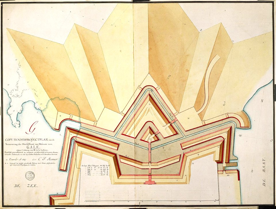
maps of the dutch east india company - sri lanka
carel frederik reimer
geographia universalis (1545) in the british museum
german renaissance,northern renaissance
geographia universalis (1545) in the british museum
german renaissance,northern renaissance
geographia universalis (1545) in the british museum
german renaissance,northern renaissance
4901 - 5000 of 9,296
Next page
/ 93